Case Study – Usage of Earth Observation imagery to detect illegal dumping
SHARE ARTICLE:
The Sentinel series of satellites are part of the European’s Commissions Copernicus program, which is tasked with providing the public and private sector with Earth Observation (EO) sensor data and imagery for a range of different application areas. Concerning the usage of these satellites in the domain of illegal dumping, the most relevant Sentinel satellites are ‘Sentinel-1’ and ‘Sentinel-2’.
Sentinel-1
The Sentinel-1 series consists of two satellites known as Sentinel-1A and Sentinel-1B. They provide an all-weather, day-and-night synthetic aperture radar (SAR) imaging capability for land and ocean applications.
The major benefit is that they use Synthetic Aperture Radar, which can see through cloud cover. Each Sentinel-1 satellite is in a near-polar, sun-synchronous orbit, with a 12-day repeat cycle and 175 orbits per cycle. Both Sentinel-1A and Sentinel-1B share the same orbit plane with a 180° orbital phasing difference. Because they are sharing the same orbit, it reduces the repeat cycle by half. Therefore, the two-satellite constellation offers a 6-day exact repeat cycle.
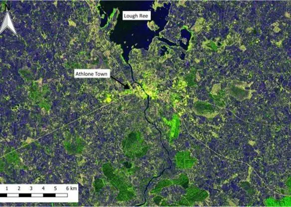
Sentinel-1’s SAR instrument can provide a resolution of 3m-10m.
Sentinel-1 Radar Image of Athlone
Sentinel-2
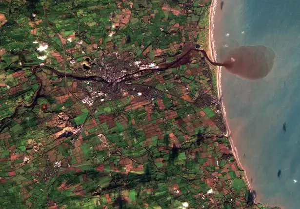
Sentinel-2 Image of Drogheda
Sentinel-1 satellites provide medium resolution optical image data to support Copernicus Land Monitoring services, including monitoring vegetation, soil and water cover, and observation of inland waterways and coastal areas. The Sentinel-2 series also consists of two satellites known as Sentinel-2A and Sentinel-2B. They have a revisit time of 5 days and provide images up to 10m resolution.
Automated Usage and Detection for Illegal Dumping
Sentinel satellites provide support to land monitoring services and ensure frequent and systematic coverage to support the mapping of land cover, classification and change maps, and accurate assessment of geophysical parameters.
With land change maps, it is easy to identify developments in the land, such as building new structures and deforestation. By observing time series patterns in a sequence of images, it is possible to detect these changes. EO data can be used to detect illegal dumping by using change maps in conjunction with geospatial algorithms to detect waste. Changes can be detected based on the lack of growth of vegetation within a particular area relative to other areas and detection of other land changes at each overpass.
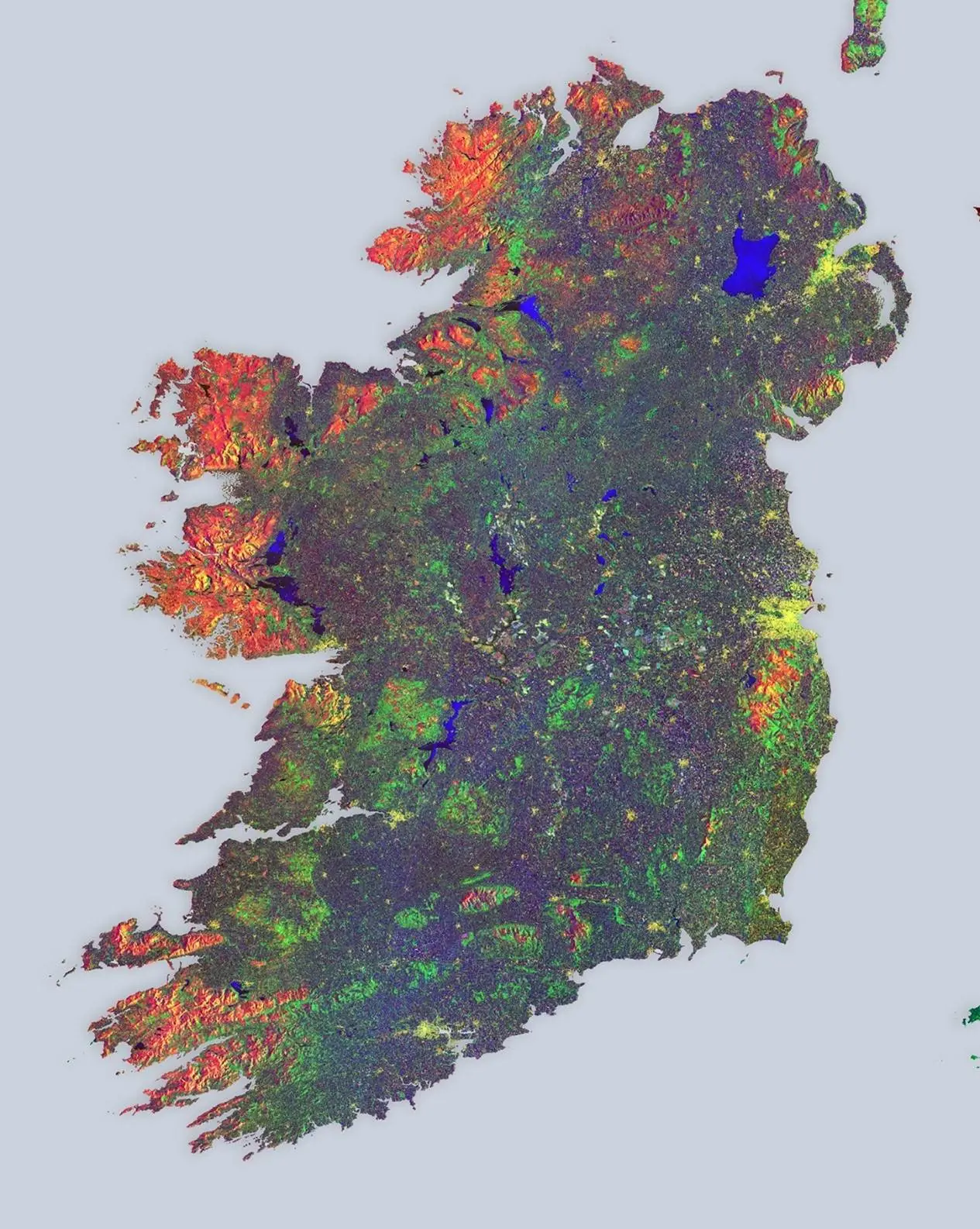
The example shows the typical time-series image that can be produced from Sentinel-1 SAR data. Different colours show changes that occurred within the coverage period that is being analysed. Automated algorithms can analyse the detected sub-images that make up this composite image and alert areas of unusual land usage patterns, i.e. lack of vegetation growth etc., relative to surrounding areas. These areas can be highlighted to an operator for further investigation by acquiring higher resolution imagery over specific/smaller areas, as well as a site.
Time Series map from Sentinel 1 where different colours represents the rate of change of the land usage and vegetation growth. Copyright: Copernicus data/ESA (2016)
Skytek within an ESA funded ANISTIAMO project developed algorithms for the analysis and automated extraction of information of Earth Observation images. Within ANISTIAMO these algorithms were applied to images of the ocean for the detection of vessels through their engine wakes. These algorithms have been modified for the detection of land usage and analysis of time series data which are applicable for the detection of illegal dumping.
Skytek today announced the launch of its new Compliance Intelligence Report Service, a continuous monitoring service designed to help marine insurers,...
This surge has created a significant accumulation risk. More than 60 vessels are now clustered around Yanbu, representing over $2.5Bn in marine hull exposure....
Strangling of the Strait: On February 28, 2026, sixty vessels exited the Persian Gulf through the Strait of Hormuz while thirty‑one attempted entry — ninety‑one...
The security environment in the Persian Gulf has undergone a fundamental structural shift following the escalation that began on February 28, 2026. For...
Prior to the escalation of the Iran conflict, maritime exposure in the Strait of Hormuz was significant. On 28 February, a total of 89 non-sanctioned vessels...
As of March 2, 2026, the Middle East is in a state of high-intensity conflict following the joint U.S.-Israeli military operation on February 28. In retaliation,...
Recent developments in the Strait of Hormuz have raised immediate concern across maritime and insurance markets. Reports indicate vessels are being denied...
$22B OF MARINE HULL IN THE PERSIAN GULF: From a maritime insurance standpoint, the impact is immediate and continuing to evolve. More than 900 insured...
100,000 Orbits: When the Columbus laboratory launched in 2008, it marked a new era for human spaceflight. Behind its success is Skytek’s International...
This year marks 20 years of IPV+ software operating aboard the International Space Station (ISS), a major milestone in its continuous contribution to human...